The Short Version
- Two hour drive from Calgary to Banff National Park
- Dinner and hand-crafted cocktails at Nourish Bistro (vegetarian)
- Camping at Johnston Canyon Campground
- Bourgeau Lake hike to Harvey’ Pass to Mt. Bourgeau Summit
- Bow Falls
- Park Distillery and Resturaunt
- Icefield Parkway drive to Peyto Lake access trail
- Lake Louis, Lake Agnes, Big Beehive
- Lake Moraine
- Johnston Canyon Falls hike to Ink Pots
- Silverton Falls
- Grizzly Paw Brewery
The Long Version
I tried to add filters to my photos. I tried to enhance the colors. I maxed out the color saturation but the picture did not change. The vibrant blues stayed vibrant, the lush greens stayed lush. The grays didn’t get grayer and the whites didn’t get whiter. Before visiting for myself every time whenever I would see an iconic photos of a lake (you know, the one of the someone in a canoe surrounded by water starring into a massive mountain) in Banff I didn’t believe the beauty captured by the photo would be fully replicated by the real thing. The water cannot really be that color blue right? wrong
Friday, May 25th: The reason I decided to live in Calgary for a month was based primary on the fact that I wanted to explore Banff National Park. I wanted multiple weekend in the backwoods of Banff but various travel timings would allow me only one totally free weekend. Fortunately, it was labor day weekend so I would get four full days to spend. So after checking out from work early and grabbing a quick workout, I started driving west with my camping gear and Red Bull. Banff National Park is a straight shot 80 miles east of Calgary. Quickly into the drive the skyscrapers turn into the Canadian Rockies. I was greeted by a line of cars at the entrance to the national park. Being a long weekend I was not surprised a lot of people wanted to spend it the same way I did. After a short wait and $40 Canadian dollars later I had my permit and was in the park.
I had a camp site reserved in Johnson creek canyon campsite, but before heading there I stopped in the town of Banff located a short drive down the road from the park entrance. It is a touristy little town that caters to parks visitors with a array of hiking gear stores, hotels, restaurants and souvenirs shops. It is really clean and manicured town, but that was not surprising since you have to literally pay (park fee) in order to have access to the city. Parking is free but driving slowly is impartive because pedestrians are walking everywhere and they have the right of way throughout the city and no fear of exerising that right.
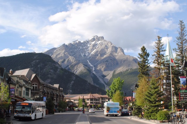
The reason I stopped in the town was because as per usual I didn’t really know what I was doing and wanted to ask a visitor or information center for advice. Coming into this adventure I had to keep reminding my self that I was not going to be able to do everything in just four days. If you google best hikes in Banff you will get a different set of opinions from every website. There is a vast mixture of touristy walks, backwoods hikes and multi-day treks. To compound the decisions there are actually four parks in this area: Banff, Yoho, Kootenay and Jasper (and some others). Whenever I asked people in Calgary or friends they would list off an array of hikes, most of which were not even in Banff and they would always be sure to add “oh make sure to go to Jasper, its better than Banff and less touristy.” This is when I would repeat to myself I cannot see everything in four days. My rough plan was to do a summit hike followed by some touristy hikes followed by some flat hike followed by some short roadside hikes. I had narrowed down the summit hike to three options: Mt Temple (highest point in Alberta), Mt Massive or Mt Rundle (in order of difficulty). However, still being early in the summer season (May) I didn’t know if any of these hikes were even accessible. I barely have camping equipment so I definitely do not have gear for trekking through snow or rescue beacons for avalanches. Not to mention I do not even possess a map of the park (I downloaded the a google maps map, but its not the best for finding trail heads). Again, as per usual I got to the town later than expected, 8pm, so all the information centers were closed. I ended up walking into a Patagonia to ask to the woman at the cash register for advice.
“Mt. Temple still snow covered and one part is a little narrow (when without snow) where most people rope in.” Maybe not the best idea to do that one…
“Mt Massive might be ok, I don’t actually know, took me ten hours to hike it last time I went. Be sure to go with someone that knows the shortcuts.” Well, I don’t know anyone and that would kill one whole day…
“Mt Rundle is pretty clear, people are doing it now, I have never actually done it so I don’t know if it is worth it or not.” Well darn…
“but Mt Boureau and Mt Mac are cool, don’t know if they are accessible this early though.” Great start…
When in doubt I always feel the best thing to do is grab food and something to drink. So I went to a place called Native Tongue which serves a totally vegetarian menu and is known for fantastic cocktails and they did not disappoint. From here I admitted planning/information defeat and headed 10 miles down the road to check into my campsite. There is basically one very nicely paved and painted road that spans hundreds of miles through Banff and Jasper. Johnston Canyon Creek Campsite is located a couple miles off this main road. There are five-ish campgrounds in Banff with 30-100 campsites at each one. The previous night I couldn’t discern any really difference between the campgrounds so I just reversed a spot basically at random for $25 a night (can reserve through the Canada parks website). The campsites were not as full as I expected so I didn’t have to reserve a spot before hand but for once I actually did). It was a typical campsite with a picnic table and a small fire pit with other campsites in every direction and trees scattered throughout. Clean restrooms a stones throw away. Pitched my tent, unrolled the sleeping bag and set my alarm for 6 am.
Saturday, May 26th: Of course I didn’t wake up at 6 am. It amazing how hard it can be to go to sleep when sleeping on the ground but how hard it is to wake up after waking up every couple of hours throughout the night. My next investment will be in a sleeping bag mat because i keep suffering from cold butt syndrome.
Anyway, I decided to start the day with a hike rated online as ‘difficult’. Bourgeau Lake to Harvey pass is a 12 mile out-n-back hike to a glacier lake and a Rockies outlook point between two mountains (Harveys pass). The trail head is right off the main road but I still managed to pass it even though a it has a obvious sign (dont follow google maps). The extra 5 miles of driving would have been a lot worse if it wasn’t for the scenery to keep me entertained. There is a small parking lot t the trail head that only had one other vehicle which I was happy about. However, this feeling of meditative solitude to come turned into a bit of nervousness as I was greeted by a large, heavy metal gate with various warnings notifying hikers that they are entering the backwoods Banff. The gate slammed shut behind me and proceeded up the trail.
The weather was perfect being in the high 70s. I was worried about it being cold but it almost hot. There was not a cloud in the sky but the trees provide a good amount of cover from the sun so I was very comfortable. One mile in I came to the first small snow crossing. As previously mentioned I was not prepared for snow hiking but it only stretched for 20 yards and was very compacted snow. Looking up the snow field that extended up and down the mountain I could see small waterfalls cascading down. There were a few more similar crossings over the next couple of miles that were no problem. At this point I was feeling that this hike would go as expected in that I would be done in under four hours off to my next hike. The real ‘fun’ began when I reached the first water crossing. Ice melt had created a pretty swift stream that rushed past the trail. This is where I caught up with another hiker walking away from the water back towards me.
“Is it cold?” I inquired sarcastically.
“Ah I didnt cross, I chickened out, I’ve been up there 50 times before and don’t feel like getting wet today.”
Fair enough. I preferred not to walk through the freezing water but there really was not any other choice. Off came the socks and into the water went my tennis shoes. The current was strong but not deep (ankles) so nothing too miserable. Once on the other side I saw the hiker that had ‘chickened out’ following me across the stream. I guess he changed his mind which was fine by me because it gave me some company and a guide. From here the ground became more and more covered with snow as we continued to climb in elevation (started the hike at 4,500ft and the lake is at 6,500ish ft). My guide that had done this hike multiple times was surprised by the amount of snow that was still on the ground. After a mile the trail opened up into a marsh and disappeared completely under the snow. At this point we could see where the lake was suppose to be in the distance because it is located at the base of bourgeau mountain which is obvious to spot. The best way to get there was not as obvious.
“I thought there use to be a boardwalk leading up to the lake, but maybe I’m thinking of another hike.”
At this point there was no avoiding walking through the snow and water as we followed the stream towards where the lake is suppose to be. We tried to tread lightly but every five steps one of us would sink thigh deep into the snow. We zigzagged trying to find the best route. Eventually, we ended up going different ways and meeting back once we eventually made it to the lake. I would say both of us took the wrong way. We hopped up on a large boulder beside the lake and gazed upon the prize. The lake was basically a
sheet of ice as it was still 90% frozen. Not what I was anticipating but beautiful none the less. The ice was cracked and jagged with some free floated pieces covering a layers of dark blue water leading into the depths of the lake. It made me want to swim out under the ice the see world below (obviously I did not). The lake was surrounded by Mt. Bourgeau and another mountain, both covered with sheets of snow, making a great backdrop to the ice encrusted lake. Part one of the hike was complete (5ish miles).
This is was the end of my guides hikes. Before he headed back down he pointed up on the side of the mountain a mile away to a section of scree between the two mountains and said that was a piece of the trail to Harvey’s Pass. All that stood between me and that one piece was a mile of trees, snow and a hundred or so feet of vertical elevation. I wearing an old pair of running shoes with no socks and a thin pair of rolled up cargo pants. Needless to say my toes were freezing, but after sunbathing on the boulder for twenty minutes watching a chipmunk run around my pack (containing food) I decided to give it a go. If it was unpassable I would just turn around. I started trudging through the woods in the direction of the trail, which was quickly lost in the screen of tree. I would basically scamper from ‘dry patch’ to ‘dry patch’ until I made it to the edge of the trees and to the base of the mountain. Every five steps resulted in me stepping throug the snow into the cold swamp of snowmelt underneath. Up the mountain side were what seemed to be footprints through the snow. I followed the footsteps up a short distance until I came to a snowless section where the prints dissapeared. From here I traversed along the side of the mountain towards where the path was suppose to be. At one point I thought I was following someone’s path, but I am pretty sure it was just where a shelf of snow fell down the mountian. Hoping that it would not fall again I continued around a boulder until I came again to someone’s footprints. If I didnt find those footprints I most likely would have turned around. The prints told me two things: 1) Someone else has done this already and 2) Since there was one set going out and not a set coming back maybe there was someone else out still hiking that I would run into. In hindsight number two was not the most intellgient conclusion to come to but I was hopeful. Through the white sheets of snow I continued with every five steps collapsing me knee deep into the snow. After an hour of this process I made it to, and past, the peice of trail that gave me hope when I started. Over another short ridge I was greeted by Lake Harvey and two guys hiking towards me. They rejuvenated my spirits by informing that the rest of the way to the pass safe and that, though they didnt, I could continue all the way to the summit of Bourgeau. Also, informed that I did follow thier footsteps up there and it was technically the wrong way but their path would lead the rest of the way and the correct way back down. Despite the facts that they were wearing dry boots with appropriate hiking attire (and bear spray and emergency signal beacons) and that next stretch would be the longest stretch of unintrupted snow to this point and that this would mean I was definately alone out here…I decided that I had made it too far to turn around. On I went one step at a time through the snow path. The next section would be the most miserable (so far). At points I would fall both feet into the snow waist deep. For the first time in my life I realized that getting stuck in snow was a real thing that happens in the real world.
  Fortunately, earlier I had picked up a walking stick which I used to helped pry me out of some snowy situations. Up one last curtain of snow I had made it to the awe-inspriring presapis of the hike that laid out the uninterupted rockies before me. I dont actually know where Harvey’s pass tehnically was, but this had to be basically it. Behind me was the crystal like Lake Harvey sitting inside of the porcelain white bowl of the mountain with only one crack running through it being the my path. In front of me was a jagged horizon of peaks. Part two of the hike was complete (6.5 miles in).
Looking up at Mt. Bourgeau from the Lake Bourgeau it looked impossible to reach the summit safely because appears to be completely covered with snow along the entire ridge. To my suprised the hikers were right inthat that back side of mountain was clear of snow. Though the elevation climb was duanting at this point I was excited to not be walking through snow. I had made it this far, I might as well see climb to the top. The next mile of hiking was scrambling up 2000 feet of rock scree past one false summit and one short snow crossing to the peak of Mt Bourgeau. No special signs waiting to congratulate me at the top, Just some a small weather station and cairn. That did not matter to me at that point, all that mattered was the stunning view and the summit pb&j I packed that I was finally allowed to eat. Part three of the hike was over (8 miles in).
Getting back down the mountain was pretty straightforward, but I wouldn’t say it was  any easier. I was dreading the toe freezing journey back across the snow and it did not disappoint. On the downhill sections I tried to slide down on my backside. This worked with limited success. Majority of the ‘sliding’ was me scooting my butt across the snow until gravity took hold. One part I gained enough speed that I become slighty anxious because the slide ended in lake Harvey, fortunately the snow was powdery enough that I could shove my leg into the snow as an emergency brake. I followed the path of the hikers I met back to outskirt of the thick of tree that surrounded lake Bourgeau.
 This next section was very frustrating because I was mentally exhausted and just tired of not being able to feel my feet. I had slid down to a location other than the way I come in so I didn’t exactly know how far I had to go in order to get back to Lake Bourgeau. After yelling many F bombs I made it back to the frozen beauty of Lake Bourgeau. From here every mile for the next five mile became increasingly easier. Finally, with just under three miles to go my feet were able enough and the terrain was safe enough for me to finish the hike by running. The intially planned 11 mile hike that I estimated to take 3-4 hours was finished 8 hours and 16 miles later.
I was not in any mood to do another hike at this point so I headed back into the town of Banff to see Bow falls that is located right behind the town. Tourists can drive right up the falls which was fine by me. The waterfall is not tall but is still impressiveness because of the force and volume of the water cascading down. I topped my first full day in the park by a Gin flight night cap Park Distillery and Restaurant in downtown Banff.

Sunday, May 27th: Peyto Lake is a popular picture spot on the Northern end of Banff. Most pictures of this lake features a person standing on a perch overlooking the petite blue lake which rests in front of the Canandain rockies backdrop while they contemplate the meaning of life. This (and other touristy easy to get to spots) seemed like a smart alternative since Saturday consisted of ill advised hiking alone in the Banff backwoods.  Peyto lake is 40ish miles North of Johnonston Canyon via the Icefields Parkway (the main road going through Banff). The Icefield Parkway connects Banff to Jasper National Park with 150 miles of unimaginable scenery and is often tauted as the most scenic drive in Canada. I was not sure exactly where this ‘popular’ picture spot was and it didnt exactly jump out at me (looking back im pretty sure I should have headed to ‘Bow Summit’). I pulled into a unmarked, small and empty lot on the left side of the road hoping to see a sign. There was no sign but there was a small path leading into the trees in the direction of the lake. Diving into the path the smell of pine and spruce tree immedialty surrounded. I followed the trail for about a mile as it winded through the lush and moss covered trees, past patches of snows and over gentle creeks until the curtains of trees opened up to a gem laying in front of me. I was not on a perch overlooking the lake but rather at the edge of it. Crystal clear water turned different shades of blue as it recended further away from the shore. It felt as though I had the entire lake to myself. I was bewitched with peace and solitude while I sat next to the tranquil waters of Peyto Lake.

Eventhough Peyto lake is popular, Lake Louis might be the most photographed lake in Canada if not the world. Looking at pictures one would think it is a beautiful secluded lake tucked beside the rockies. However, something that It was not until a couple of weeks prior did i realize there is a massive resort right on the lake and multiple parking for miles around to host the thousands or tourists that visit weekly. I started to think I had made the wrong decision when I had to wait in traffic and then drive around to find an open parking spot, but since I already there might as well check it out. Short walk from the parking lot (at least the one I parked in) put me right between the massive (and expensive) hotel and the edge of the lake. I’m not going to lie it is a beautiful scene looking out over the lake as long as you do not turn around. As much as I am complaining about the monitization of nature, I did go to the hotel’s cafe and enjoyed a cup of coffee while sitting on their terrace.
From the base of the lake there are a variety of hikes available depending on how much walking/hiking is desired. One of the iconic hikes is the two mile up-hill trek to Lake Agnes and the small tea house next to it. Yes, you can reward yourself with a cup of tea once at the lake. How do they get the supplies up there? No idea, but doubt it is by helicopter. The hike was crowded but still a nice speed walk on the well maintained path. Lake Agnes is smaller version of Lake Louis in every aspect except that the water is distinctly greener than the surprisingly blue water of Louise. This probably has something to do with the glacier runoff differences between the two and there was definitely a sign explaining it somewhere but missed it.
The Tea house doesnt actually open until June, so I didnt get to enjoy a meditative cup of Oolong tea, but there happened to be a couple of park rangers selling giant gooey chocolate blobs. I inquired about the Big Beehive (Little Beehive was open as an alternative) hike which connects to the Lake Agnes trail and leads to a lookout point. The ranger pointed hundreds of feet to a buldge in the mountain side and said “that is it up there, but the trail is completely snow covered. It is on a avalanche ally over there and you would have to slog through waist deep snow. I wouldn’t advise you doing it in running shoes” as she eyed my feet. Challenge accepted.
Within in minutes of walking I was met with a layer of snow. Fortunately, at that time a couple walked past me.
“You guys going up to big beehive?”
“Gonna try” and off the three of us went. At least this time I was not doing it alone. We made it around the lake to the base of the vertical portion of the hike. Deju vu set in because we had no idea where the trail was but we did see a snow path leading directly up the side of the Beehive. Digging our toes into the snow step by step we forced up the 500 foot avalanche ally thinking it was the trail. We realized near the top that the actual trail is a long series of switchbacks weaving up the side the beehive and not a direct ascent. Whoops, well this way more adventurous and the worse that could happen is that we slide hundreds of feet into the frozen lake below. 
The view from the top was mesmerizing. Lake Agnes and Lake Louise are visible from the edge of the beehive and really shows the distinct contrast in the two pools. A carpet of tree pave the landscape leading into the rockies on the horizon. Step behind the Gazebo for the best view angles.
From the top we could either go back the precarious way we came or head down the other side. The other side would lead into the 6 glaciers hike which is a long in and out hike into the valley behind lake lousie (and actully to another tea house somewhere back there). I wanted to do this hike but it to was reportedly snow covered. I had already made my way through two ill advised snow treks so I was not keen testing a third, but the deciding factor was that the two hikin companions were interested in heading back so I followed suite. The hike back to Lake lious was a couple miles longer than the way up consisting of long switchbacks down the beehive. It was a longer route but much less snow covered making it pretty easy. At a couple of points in the trail there were pathways of trees that were snapped in half and foliage debree makig it seems like tornado swept through. It actually the result of avalanches and seeing this really puts into perspective the destructive power that falling snow can have. The trail eventually joins the edge of lake Louis and follows the a paved bank back to the hotel. This section is also a popular spot for rock climbing as we saw 4-5 different sets of climbers scaling thier way up the side of the beehive (or whatever moutain that tynically is).
Moraine Lake it also a very popular spot for iconic photos that is just a 15 minute drive down the road from Louis (even though google maps said it would take 58 minutes to get there it was actually about 11 minutes). The drive to the lake was a winding paved road that decended into the forest and mountains. This short drive was for some reason really spiritual. I am not sure if it was the soothing Leon Bridges playing or just the forest flowing around me as I let the gravity take the car down the road, but whatever it was put me in a tranquil state of mind.
This lake is also on the touristy side as there is large parking lot at the lake with some cabins and a cafe. At the lake there is a short trail that goes for about a mile up a rock pile giving great views of the lake. Though there is a trail going up the rock pile most people (me included) just scramble up the rock pile to the top, then scrample down to the base of the lake for water level photos. This lake is not as large as lake but might be more striking in its bueaty as it is surrounded by 8 peaks that peirce the sky. Moraine was an even different shade of blue than Louis or Agnes, a darker blue. At that time it was in a state of transition from being forzen to liquid so there were streaked of ice set uniformly aross giving the lake a really complex texture. I got lost dazing at the scene.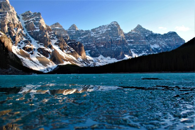
There are many hikes that start at Lake Moraine ranging from easy walks to multi hour hikes such as _______.
Most of the interesting hikes seemed to be still snow covered from my research and the sun was setting so I decided to call it day and headed back to the campsite.
Monday, May 28th: This was my last day to spend in the park and I had been putting off one hike in particular because it was so close to where I was camping. Johnston Canyon Falls hike pops up on many lists of must do hike and was suggested by multiple people as a must do. After I woke up and packed up my campsite I drove the .8 miles down the road to the trail head. I knew it was a popular hike but amount of people on the trail was surprising. The trail is very well maintained and even has railings. This makes it a good hike for travelers looking for something easy. The hike goes for less than a mile with some slight elevation until reaching the first waterfall where you can walk through a little tunnel to get closer to the falls. The trail then leads further up the canyon to the upper falls and this is where the hordes of people that started the hike really thinned out. I guess majority of people only make it to the lower falls. At the upper falls is an overlook that looks down at the waterfall but right before the switchback to the overlook is a ‘trail’ (looks more like a illegal climb down) that leads down to the base of the bottom part of the falls which is where the best photos are taken. This is not really trail and can be easily overlooked, but we were able to find a path the to scramble because we knew it was possible and that seemed like the only feasible place to do so.
 After the upper falls the trail extends another 3 km up through the forest until reaching the ink pots. The ink pots are interesting, but I am still on the fence as to whether the extra hike was worth it though it was nice to sit by the river and enjoy to the open scenery. The ink pots is where a lot of hikers start longer multi-day backwoods hikes..
Less than a mile down the road from the Johnston Canyon trail is the start of the Rockbound lake trail. The hike to Rockbound Lake is about 10 miles, which was about 9 miles more than I was up for at this particular moment. However, this is also the start of a .7 mile hike to Silverton Falls. For some reason the 150 foot tall Silverton Falls is a much less popular falls than those in Johnston canyon even though it seemed to me to be more spectacular (but maybe that was because of the tranquility created by the absence of other hikers). There were only two other cars in the small parking lot compared to the hundreds in the parking lot down the road. The hike starts on the same trail as the Rockbound Lake Trail, but splits off to the right a couple hundred meters in. There are smaller ‘trails’ before the Silverton Trail split that lead to confusing alternative routes which I accidentally embarked on. This extra hiking is easily avoided by not splitting-right until reaching a fork in the trail with a sign that clearly states the direction of Silverton Falls.
The trail turns into short but steep switchbacks about half a mile after turning until ending at the middle of the waterfall. Some scrambling leads to a up close view of the waterfall. If lucky the tree that had fallen over to span the waterfall canyon will still be present to make for a comfortable front row seat to the beauty that is Silverton Falls.
I wanted to keep hiking for the hours if not days but reality was calling so I cut the cord and headed to back Calgary. For one last taste of the Rockies I stopped at Grizzly Paw Brewery in the town of Canmore just outside of the Park. I sat on the patio enjoying a of pint of Beaver-tail Raspberry Ale while soaking in the last views of the towering Rockies on the horizon.
(if you made it to Canmore and decided that you need to scratch that last itch one more time check out heading to the top of Mount Lady McDonald ‘Lady Mac’. A local at the brewery mentioned it and it upon investigation it looks to be a pretty adrenaline pumping hike that features a narrow and dangerous ridge traverse to the summit. It’ll be first on my list when I return.)

 living arrangements didn’t work out leaving this to be another weekend excursion. The Zion area is a four to five hour drive North West from flagstaff. There are actually two ways to get there. the direct route is North past Page and up into Utah then across. The second route is 20 minutes longer but is in my opinion the better option because you can stop at Jacob’s Lake Inn/Lodge in Jacob’s Lake. Park, walk in, go to the bakery counter to the left and ask for one of every cookie (about 14 kinds). Why? Because they are crazy good. I ate about half of them and gave the other half to people I met to make instant friends.

 (for cars) and grants entry for a week. Just past the entrance on the right is the visitor center and shuttle buses. From the map (that they give after purchasing a pass) I could easily tell where I wanted to go (Angel’s Landing Trailhead), but I soon found out that you cannot drive up to the trail head, that privilege is reserved for the shuttle busses. So, I turned around and went back to the visitor, parked, hopped on the shuttle and was at the Angels Landing Trailhead 25 minutes later.
 After another hundred yards the path turns into a steeper set of switchbacks for another couple hundred of feet. At the top of this it will feel like the hike is almost over because the its less than mile to the end. However, the rest of the is slow going because the trail is steep, narrow and can get congested. The remainder of the hike is a guided by a metal chain that winds up the canyon. Some parts get very narrow with thousand foot drops off either side and some parts consist of easy rock scrambling. After a mile of up, curves and climbs I finally arrived at the peak of Angels Landing. An astounding lookout to the vast glory of Zion Canyon. The peak is actually not at the top of the Canyon, but this makes the scene more mesmerizing because I was still engulfed in the canyon while gazing at the green and brown valley that lead into the vanishing horizon. There were 20+ people also Angles Landing, but even though it is a small space it wasn’t very hard to get an unobscured viewpoint and picture. The trip back down is the same as the way up which would be simple if it wasn’t for the people coming up the trail. After waiting in lines, I started to make unadvised shortcuts to jump ahead of people. Then once at the switchback I actually found it easier (funner (not a word I know)) to run the rest of the way because of the steepness. Despite its popularity, the hike was still exciting and I definitely still consider it a must do. If you are debating doing it because of the steepness and narrowness of trail I would say go for it. I saw all types of people and I met people that claimed the be deathly afraid of heights that made it to the top. Yes some parts are narrow and yes its thousands of feet on either side, but grab the chain, take a deep breadth, look up and put one foot in front (directly in front) of the other and you’ll be at the top in no time (besides it is the way down that you should be scared of because you will staring all the way down the whole time). Only 7 people have died on the trail…
 nothing at the top of the hill to the right…thanks sir. I followed the ridge to the left with all my junk until I got to another parking lot and another split in the road. I chose poorly again. After two miles of walking up and down the valley (which I guess was Moe’s) I finally found boulders slapped with white chalk (actually not that hard to find if you know where to look). By this time the sun was starting to set so I climbed by myself for less than an hour. There are a wide variety of routes and problems, but I stuck to a couple of routes to fail at. Except for a couple of people on motorcycles I didn’t see any other until I was about to leave. The sun past the horizon before three people walked past me from further up in the Valley…turns out there is better bouldering further up the Valley.
 I actually started the hike two other people that I met on the shuttle. The three of us stepped into the water and braced ourselves for the cold water to fill our socks. After the initial chill, we started the journey upstream. The hike is gorgeous. The river twists and turns through the red-brown sandstone walls that tower thousands of feet. The water alternated between a gentle flow and a powerful rush as we trudged through. Wide straightaways would morph into 20ft wide alleyways. I hiked with the two companions for a couple miles as a pace slower than I desired so I jumped at the opportunity when another solo hiker went flying by. Its was awkward ditching my new hiking companions but I’m sure they understood…(it was more awkward when we crossed paths later in the hike, ‘Oh hey, ya I don’t know what happened I turned a corner and you guys were gone when I looked back’). A couple miles into the hike there is a slot canyon that splits off to the right. This route goes for a couple miles over a few small waterfalls. We hiked until we reached a 6-foot waterfall that we were not able to climb over. We could have made it
 over with some more effort but we also knew this was technically the park mandated turn around point (back country permit required for hiking further). We scrambled back up the main canyon for miles until reached the campsites. It was a lot of fun scrambling over rocks and trying to find the routes that save us from having to go for a swim (the deepest we had to walk through was about waist high). If our rental equipment didn’t have to be turned in by 6 pm we would have kept going up the Canyon, but we decided to head back. I usually find the backs of the out and backs are boring as I retrace my steps but this felt like a completely new hike. It was around 4pm when we got back to the start which was now crowded with people staring down the Narrows. In total the hike was 21 miles over a 7-hour period.
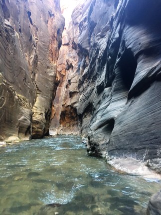


 hike but is really not bad). Pro-tip if you do the primitive hike, go right when the main trail splits between the the primitive loop and the landscape arch lookout (picture). Most people would say this is dong the loop backwards but doing it this way you get the monotonous desert part of the trail done first and save the scrambling, arches and lookouts for the end.
 have been much more owe inspiring if I was there earlier. The arch was not as big as I expected, but it was still magnificent in the sense that in that it was an overlooking window to miles of canyon landscape.